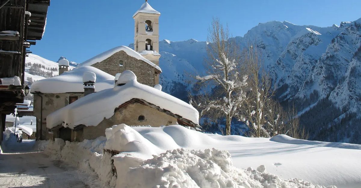
The Queyras isn’t just a valley. It’s a designated regional natural park located deep in the Hautes-Alpes department of Provence-Alpes-Côte d’Azur. The Guil River cuts right through the center of it. Today, eight specific communes make up the local community. Arvieux. Abriès. Aiguilles. Ceillac. Château-Ville-Vieille. Molines-en-Queyras. Ristolas. And Saint-Véran.
That list feels complete. It’s tidy.
But it’s technically inaccurate if you look at history. Ceillac is the glitch in the matrix.
It didn’t belong to the historical Queyras. It wasn’t part of the Escarton du Queyras—the old administrative division that defined the region’s identity. Instead, Ceillac fell under the jurisdiction of the Bishopric of Embrun. Not Briançon. Embrun.
This distinction matters. It’s not just bureaucratic trivia. It explains why Ceillac has a different cultural and administrative lineage than its neighbors. The other seven communes shared a common legal and social structure rooted in the Queyras tradition. Ceillac operated under a different ecclesiastical authority.
Why does this matter now?
Because the modern community of communes groups them together for practical reasons. Resource sharing. Tourism coordination. Administrative efficiency. But the historical boundary remains. You can trace the shift in local identity. You can see it in old records. You can feel it in the subtle differences between the villages.
The Guil River flows through all of them now. The roads connect them. But the past didn’t draw the map that way.
This isn’t just about one village. It’s about how regions are defined. How history gets overwritten by modern necessity. How a single outlier can complicate a seemingly simple story.
The Queyras valley is more than a scenic drive. It’s a palimpsest. Layers of history stacked on top of each other. Sometimes you can see through them. Sometimes you can’t.
And Ceillac? It’s still waiting for its own chapter.

Roots in Dauphiné and Occitan culture
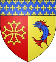
The coat of arms for Hautes-Alpes tells a political history through symbols. The dolphin links the department directly to Dauphiné, a province that became part of France in 1349. You can see this lineage in the top section of the shield, which is scattered with fleurs-de-lys.
Then there is the cross of Toulouse. It is a nod to Occitan culture. The region was originally Provençal. This heraldic detail acknowledges that deep historical tie to the south.
How Cipra shapes alpine sustainability
Cipra is an acronym. It stands for Commission internationale pour la protection des Alpes. For fifty years, this group has pushed for sustainable development in the alpine zone.
Why bother? The stakes are high. About 13 million people live across the Arc alpin. The range stretches 1,100 kilometers long. It cuts through eight different countries.
The group does not just protest. They look for solutions. They try to balance three competing needs. Ecology. Economy. Social interests.
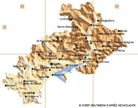

Where the French Alps Alliance Calls Home
Grenoble. It is not just a dot on a map. It is the largest urban cluster in the entire Alpine region by population. And it serves as the command center for the French committee of the International Commission for the Protection of the Alps. You know it as Cipra. Or maybe you’ve never heard of it. But the group operates with a heavy hand against the clock, working with actors from every single French Alpine region.
The strategy is not subtle. It is ambitious. The association takes hard positions. They are not here to watch. They are here for sustainable development. They are here to defend the heritage of the mountains. Natural heritage. Cultural heritage. The snow. The stone. The history etched into the valleys.
“The committee acts as a pressure group for the soul of the Alps.”
Think about that scope. Grenoble sits in the heart of the French Alps. It is a hub. From this hub, the committee reaches out. They talk to local governments. They talk to tourism boards. They talk to the people who live in the high altitudes. The goal is protection. Not just for the glaciers, though they are melting fast. But for the culture too. The way of life that depends on those glaciers.
Why does this matter to someone reading this from a flat city? Because the Alps are a water tower for Europe. They are a climate regulator. And they are a massive economic engine for tourism. When the French committee pushes for sustainable development, they are trying to balance the ski lifts with the snowpack. They are trying to save the old villages from being swallowed by resort sprawl.
It is a fight against erosion. Of land. Of identity. The committee uses its position in Grenoble to coordinate this fight. They gather data. They set standards. They push policies that prioritize long-term survival over short-term profit. It is a heavy lift. The mountains are changing. The people living there are changing. And the committee is the lever trying to keep the balance.
The Fight for Alpine Balance
The work happens in the margins of policy meetings. It happens in public statements. It happens in the quiet lobbying of officials who control land use. The French committee of Cipra does not have an army. They have a platform. And they use it to demand accountability.
Which regions are involved? All of them. The Savoie. The Haute-Savoie. The Isère. The Hautes-Alpes. The Pyrénées. Wait, the Pyrénées are separate. But the French Alps are contiguous. The committee covers the entire French arc. They look at the big picture. They see the connections between the water sources, the transport routes, and the cultural sites.
Is it enough? Probably not. Climate change is moving faster than policy. But someone has to draw the line. Someone has to say that this valley is too precious to pave over. Someone has to say that the old ways of farming on steep slopes matter. The committee says that. Every day. From Grenoble.
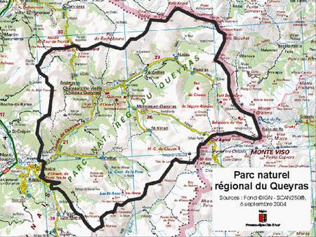

The natural park of Queyras holds secrets buried deep within its stone. We are heading toward Mount Viso. It sits just over the border in Italy, but for the sake of exploring the region, we are pretending it belongs to us. It is a small concession for a story about geology.
At the summit, you will find eclogites. These are not ordinary stones. They are metamorphic rocks that tell a violent story. Before the Alps rose up and split the sky, there was an ocean here. This ancient sea was vast. It existed long before humans walked the earth. The eclogites are the remnants of that lost world. They were pressed deep underground by tectonic forces. Then, the mountains pushed them back to the surface. Seeing them is like touching history itself.
But looking at rocks requires preparation. The mountain does not care about your intentions. It demands respect.
Why These Rocks Matter to Geologists
Eclogites are rare. They form under high pressure and moderate heat. This specific combination happens deep in the Earth’s crust. Typically, it occurs during subduction zones. One tectonic plate slides under another. The rock is crushed. It changes color. It turns from grey or green into a striking mix of red and green.
The red comes from garnet. The green from omphacite, a type of pyroxene.
Finding these rocks at the top of a mountain is significant. It proves that the rock was once miles below the surface. It was buried. Then it was exhumed. This process helps scientists map the ancient oceans that once separated continents. The Queyras is a textbook example. It shows how plate tectonics shape our planet.
Where to Start Your Hike
The park covers a large area. You need to choose your entry point carefully. The Mont Viso massif is accessible from several sides.
- From the French side: Look for trails starting from the villages in the upper Queyras. Casteldelfino is a common gateway. The terrain is steep. The paths are well-marked but can be tricky in bad weather.
- From the Italian side: You can approach from Val Maira. The views are dramatic. The ascent is longer but offers more varied landscapes.
When to Go
Timing is everything. The high altitude means snow lingers long into summer.
- July to September: This is the safest window. The snow has melted. The days are long. You have plenty of light.
- June: Possible, but watch for residual snowfields. Ice can hide under thin layers of snow. It is slippery.
- October: Dangerous. Storms roll in quickly. Temperatures drop fast. The mountains become hostile.
What to Pack
Do not underestimate the weather. It changes in minutes.
- Sturdy boots: Your ankles need support. The rocks are sharp. The paths are uneven.
- Layered clothing: Even in July, it can be cold at the summit. Wind is constant. A waterproof shell is non-negotiable.
- Water and food: There are no shops on the ridge. You need to carry enough for the round trip.
- Map and compass: GPS signals can drop. Always have a backup.

The sidebar links point elsewhere. Hiking trails. National parks. Sunken reserves.
This isn’t about that. Not anymore.
We are deep in the weeds of scientific and technological evolution. The previous sections laid the groundwork. This is the payoff. The moment where theory meets the ground.
The Reality of Discovery
“Science is not a static body of knowledge. It is a process. A messy, ongoing negotiation with reality.”
Most people think discovery is a lightning strike. Einstein in the patent office. Newton under the apple tree.
It rarely works like that.
It’s usually slow. Grind-heavy. Filled with failed experiments and wasted grant money. The real story isn’t the “eureka” moment. It’s the ten years of boredom before it.
Consider the recent strides in renewable energy storage. It wasn’t one breakthrough. It was incremental improvements in battery chemistry. Solid-state electrolytes. Better thermal management. Each step small. Each step necessary.
This matters because infrastructure doesn’t change overnight. The grid relies on stability. Not miracles.
Where the Data Goes Next
We are drowning in information. Starving for wisdom.
The next frontier in technology isn’t just faster processors. It’s better filtering. AI models that don’t just predict. They explain.
Why did the model make that decision?
Current systems are black boxes. Opaque. This is a problem for critical fields. Medicine. Law. Civil engineering. We can’t trust a tool we don’t understand.
Interpretability is the next big hurdle. Researchers are working on transparent architectures. Models that show their work. Not just the answer.
This shifts the power dynamic. Users stop being passive consumers. They become active participants. Verified. Informed.
The Human Element in Hardware
Tech trends cycle fast. Fashion changes.
But hardware? Hardware lags.
It takes years to design a chip. To manufacture it. To certify it for safety. Then years more to deploy it at scale.
This lag creates a disconnect. The software moves at light speed. The hardware moves at geological speed.
The result? Bottlenecks. Energy inefficiency. Obsolete devices sitting in landfills.
The push for modular design isn’t just environmental. It’s practical.
Right now, you can’t replace just the camera module on your phone. Or the battery. You replace the whole unit.
That’s wasteful. Expensive.
New initiatives are trying to decouple these components. Standardized ports. Universal mounts. It sounds boring. It should be. Boring is sustainable.
Why This Matters to You
You don’t need to understand quantum entanglement.
You do need to know why your data is secure.
You need to know why your internet sometimes drops.
The complex ideas in science and tech aren’t abstract. They shape your daily life. Your health. Your wallet.
Ignore the hype. Look at the infrastructure.
The quiet changes are the real ones.